[Originally published as Carnarvon Gorge was carved in two stages]
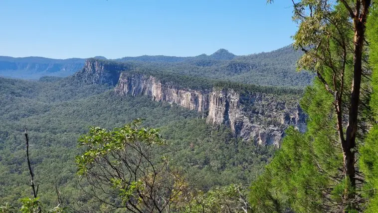
From the campground at Carnarvon Gorge, as you walk up Carnarvon Creek, the inner gorge is about 1 km wide but soon narrows to half that size. The steep cliffs of white Precipice Sandstone can be seen to tower some 200 m above the floor. Kilometres beyond the rim of sandstone, the outer walls of Carnarvon Gorge rise even higher. From the floor of the gorge it’s difficult to see through the palm trees past the sandstone to the sloping walls of the outer gorge. It’s hard to picture how much bigger Carnarvon Gorge is than the inner section that contains the creek.
The outer walls rise a further 400 m to basalt rims that cap the plateau to the north and south. At its mouth the rim of the gorge is about 6 kilometres wide. The above figure shows a cross section of the gorge.

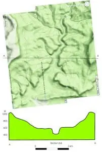 The section suggests that the gorge was eroded in two stages, both of which involved much greater water than we see in it today. The wide upper gorge with its base at about 600 metres and its top at about 1000 metres seems to have been eroded by a flow of water that was some 6 kilometres wide at the top. It suggests that the gorge was carved when the water level over the continent (the base level) was much higher, perhaps as high as 500 m.
The inner gorge with its floor at about 400 metres and its rim at 600 metres would be carved by a smaller flow of water. This flow would still have been much larger than the water flowing today in Carnarvon Creek. The level of water covering the continent would have been lower than for the first flow.
Calculating rough cross-sectional areas, the initial flow passes through a section of about 2,000,000 square metres while the reduced flow for the inner gorge used an area of some 100,000 square metres. The section of Carnarvon Creek today would be of the order of 100 square metres. In other words, a rough estimate of the ratio of flow sections compared with Carnarvon Creek is 1 is to 1000 is to 20,000.
Such evidence of reducing water flows over the continent is what we would expect to be left from the receding waters of Noah’s Flood. A similar two-stage erosive pattern is present in the Grand Canyon of the USA and has been connected with the receding waters of the Flood.
Related Articles
Carnarvon Gorge, Australia: monument to Noah’s Flood
Carnarvon Gorge rises above the waters of Noah’s Flood
Rainfall catchment for Carnarvon Gorge is not large enough
Landscape around Carnarvon Gorge was eroded in sheets by retreating floodwaters
Carnarvon Creek flows through a water gap carved during Noah’s Flood
The geological history of Carnarvon Gorge, Queensland, Australia, from a biblical Flood perspective