[Originally published in 2012 as Don Prothero’s two-gallon simulation of Noah’s Flood for the BBC Road Trip]
Don Prothero, selected as the ‘geological expert’ for Andrew Maxwell’s BBC Conspiracy Road Trip, played a little trick on the creationist team with a two-gallon ‘simulation’ of Noah’s Flood (beginning at about 8:44 on the video).
He says on his blog,

… this demonstration was very effective, and caught the smug Phil and others completely flat-footed …”
I wonder if he was not happy that Phil questioned his uniformitarian claims.
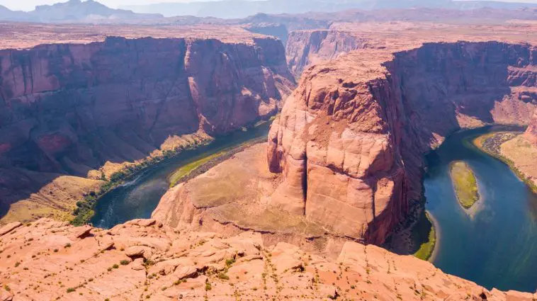
Prothero took the team to spectacular Horse Shoe Bend. He argued that the receding waters of Noah’s Flood would have flowed in straight lines, but since Horse Shoe Bend is a tightly curved meander, the Flood could not have carved it.
When the bucket of water was tipped out, the water mostly soaked into the sand, but the little that remained flowed in a fairly straight line before it too quickly disappeared — it did not meander.
A simulation is only useful if it represents what is being simulated.
In this case, it was misleading because it used an inadequate understanding of the magnitude and behaviour of the receding waters of the Flood. It also did not account for how the conditions changed as the waters reduced and as the sea level dropped.
The evidence for the receding waters of Noah’s Flood flowing from the plateau can be clearly seen in the landscape (see Horse Shoe Bend, Arizona). One needs to have a wide-angle view of the topography using a tool such as Google Maps or Google Earth. The channels cut by the waters are dramatic — more than 30 km wide. The meanders including Horse Shoe Bend were cut by the greatly reduced final flows of the Flood as sea level dropped. Their course was controlled by the topography of the surface after the main flow had waned.

Don Prothero could make a better simulation by using a surface that was not so porous.
Water won’t meander on a surface that is porous when it is quickly absorbed. A simulation also needs a surface that is not so sloped, and that contains small undulations — such as sand ripples on a gently sloped exposed beach. A small flow of water across the beach, provided it did not soak in, would meander along the low parts between the sand ripples, just like the section of canyon that contains Horse Shoe Bend.
Peter Scheele has an excellent paper on the carving of Grand Canyon by receding floodwaters in which he discusses different erosion patterns, including those by flowing water and those by draining water, and the different sorts of canyon shapes produced.
Comments and Responses
Ashleigh: “Don Prothero could make a better simulation by using a surface that was not so porous.” Except that this porous surface was encountered on location.
Walker: Hi Ashleigh,
Remember, this was Prothero’s attempt to simulate the conditions that existed at the time. I think he also agrees the water table was higher and so water would not have disappeared into the sand as occurred with the bucket. Also, there was a huge volume of water ponded upstream that continued to drain and kept the flow of water through the area. And with the bucket, the scaling factors are wrong. With the bucket the size of the sand grains to the size of the water flow would have been much larger than with the water flow that cut Horse Shoe Bend section of canyon.
J.S.: “And with the bucket, the scaling factors are wrong.” I see your point, Dr. Walker, but scalability is an essential principle in civil engineering, where small-scale models have been used for over a century.
I think the main problem with Dr. Prothero’s analogy is that he was using the wrong model. Grand Canyon and the Goosenecks of the San Jan are more accurately modeled by using water overtopping a barrier, possibly with seismic shaking occurring at the same time.
Walker: Hi JS,
I agree with you. And, yes, small-scale models are regularly used to investigate larger situations. But in fluid dynamics, all the other relevant parameters need to be scaled, such as Reynolds number, in order for the simulation to be meaningful.

Gordon: Saw a better simulation in a Sunshine Coast (Queensland) creek mouth recently. Small creek has no regular flow, so wave action builds up sand creating a dam. When a storm brough heavy rain, the creek eventually overtopped the dam and began cutting a course to the sea. The “valley” it cut in the sand was flat-bottomed, with steep (near-vertical) sides, and it widened rather than deepened as the flow increased. When the storm passed and the flow decreased, the broad flow channelized and created meanders, even with the fairly steep slope of the beach. A perfect representation of the many examples in existence at full scale around the globe!
Walker: Thanks, Gordon. Did you by any chance get some photos?
Gordon: Sorry, Tas – wish I had, but didn’t realize what was happening until it had happened.