[Originally published as The geological history of Canberra, Queanbeyan and Environs]
Recently, I visited Canberra, Australia, and checked some of the geological information about that region. I wanted to understand where the rocks around Canberra fitted with Noah’s Flood. Canberra is the federal capital city of Australia where the houses of parliament are located. It is 250 km south-west of Sydney, 120 km from the coast, and 600 metres above sea level in the Great Dividing range. Figure 1 summarises the geological history of the area based on what geologists have found as they explored the rocks.1
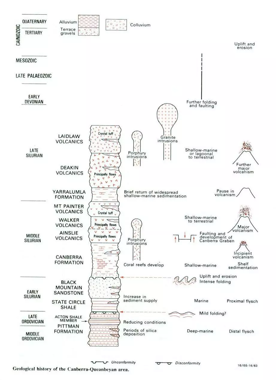 Figure 1 reveals some interesting features, but first let me explain it.

Explaining the diagram
The left side of Figure 1 shows a ‘column’ that represents the rocks described in the Canberra area, stacked one on top of the other. Each part of the column has been given a name such as Pittman Formation (at the bottom), State Circle Shale, Black Mountain Sandstone, etc. These correspond to the names of the rock formations around Canberra.
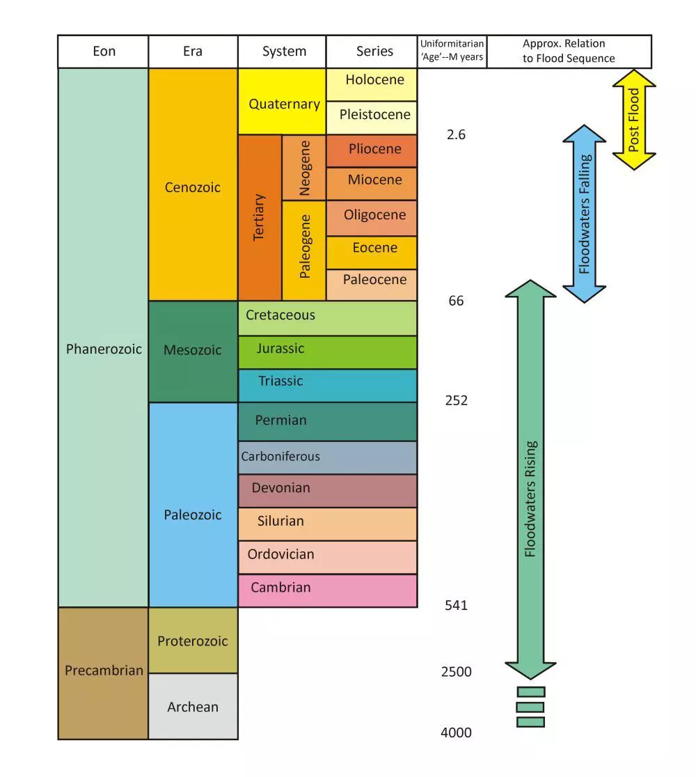
Note too that there is a timescale to the left of the column, with such names as Middle Ordovician, Late Ordovician, Early Silurian, etc. These names are from the standard geological timescale, which I have reproduced in Figure 2 so you can see how the different geological systems fit together.2 Note on Figure 2 that the Ordovician and Silurian are towards the bottom, just above the Cambrian.
On the right side of the rock column in Figure 1, alongside each different rock formation, there are some small images together with some text, such as volcanoes, granite intrusions, uplift and erosion, faulting, etc. These images and text summarise how geologists think each rock formation formed, and what happened to it subsequently.
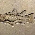
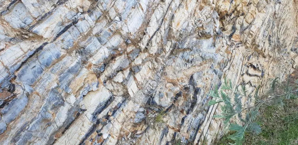
For example, at the bottom of the figure to the right of the Pittman Formation it says these rocks have been interpreted as being deposited in “deep marine” conditions and as being “distal flysch”.3 Flysch is a sequence of sedimentary beds deposited in a deep marine setting by repeated underwater avalanches, which carried sediment hundreds of kilometres across the ocean floor. The featured image at the top of this article shows a small outcrop of the Pittman Formation along Hogan Drive, Wamboin, as an example of repeating sedimentary beds that have been later tilted and bent.
One interesting feature to note on Figure 1 is that most of the rocks around Canberra sit in a relatively small portion of the geological column, that is from the Middle Ordovician to the Late Silurian.4 Notice that this part of the timescale in Figure 1 has been drawn expanded so they could fit all the rocks on the diagram. Notice too that the rest of the timescale, where there are no rocks in the Canberra region, has been truncated. These changes of scale make it easier to see the detail on the diagram and help to fit all the information on one page, but you need to be aware of the scale change.
On Figure 2, notice that there are green, blue, and yellow arrows, which specify how the geologic column relates to Noah’s Flood. The green arrow indicates the portion of the column deposited as the floodwaters were rising; the blue the portion as the floodwaters were falling; and the yellow portion those rocks deposited in the 4,500 years after the Flood. From these arrows we can see that the Ordovician and Silurian (which is what we see around Canberra) were deposited early in the Flood as the floodwaters were rising. The waters rose for about 150 days, or 5 months, so the position of these rocks on the green arrow suggests the rocks would have been deposited early in that period, possibly around 2 or 3 months after the beginning of the Flood.
Great Erosion of the Region
Notice in Figure 1 that no rocks are shown from the Late Silurian to the Tertiary, indicating that none of these rocks were preserved in the Canberra region. This indicates the whole area experienced an intense period of erosion such that rocks deposited later, in the Devonian, the Late Palaeozoic, and the Mesozoic, were eroded away.

These rocks are present in other areas of New South Wales but not around Canberra, so we expect that they would have been deposited in the area but removed by erosion. They would have been eroded by the waters of the Flood when they covered the whole of Australia, such as by powerful ocean circulation currents that developed over the continents. The rocks would also have been eroded by water currents as the water flowed off the land into the ocean in sheets. Later, as land emerged above the water, erosion would have continued in in wide channels, and finally in smaller water courses.
The Terrace Gravels
Also, of interest on Figure 1 are the “terrace gravels” that were deposited in the Late Tertiary. These have been described as conglomerate composed of quartz pebbles and cobbles with occasional boulders. These gravels were deposited at high elevation such as the crest of the Lake George escarpment, and are now only preserved as isolated patches, in places up to 5m thick.5
These gravel deposits are suggestive of deposition late in Noah’s Flood while the waters were receding from the continent. The flow of receding water, which was flowing in very wide rivers, needed to have slowed enough to allow the gravels to be deposited. Subsequent water flows eroded smaller, deeper valleys, dissecting these deposits, and leaving only patches of the gravel at higher elevations. Similar quartz gravel deposits are found on other continents deposited in this late-receding part of the Flood. (See Noah’s Flood explains boulder deposits.)
Reading the Geological History from the Diagram
Now, from Figure 1, we can appreciate how the geology of the Canberra region is explained by Noah’s Flood. Not only is it possible to connect the published geological information to the Flood, but the diagram provides insights into processes that took place during the Flood and their interconnections.
Let’s summarise the sequence:
- Starting at the bottom of the diagram, the first event recorded in the Canberra region is the deposition of the Pittman Formation. This consists of voluminous repetitive sedimentary beds (see Figure 3 for an example) deposited as catastrophic underwater avalanches (turbidites). These turbidites are dense mixtures of sediment and water that flowed down an underwater escarpment and across the ocean floor. These density flows took place one after the other, building a considerable depth of sediment, estimated at 800 metres. The evidence speaks of abundant sediment supply, repeated slumping at the top of the underwater escarpment, and underwater avalanches.
- Figure 1 indicates that crustal movements then produced mild folding of these sediments.
- After the folding, abundant sediment supply continued, and more sediment was deposited as before, building a significant depth, forming the State Circle Shale (200 metres) followed by the Black Mountain Sandstone (450 metres).
- Next, the region experienced an intense period of crustal movement, much more catastrophic than before, causing uplift of the crust and intense folding of the sediment. In places the folds are overturned and frequently bent back on themselves. This folding creates a cracking in the rock called ‘cleavage’ or ‘foliation’, which resembles the pages of a book.
- The water uplifted with the sediment needed to flow off the surface and this significantly eroded the surface. The erosion process envisaged by long-age geologists is that the uplift created a land surface that existed above water for a long period. This land surface was eroded slowly by sub-aerial weathering. The process suggested from the biblical scenario is that the surface was eroded by the water that was uplifted with the sediment as it rapidly flowed off the land.
- The intense crustal movements and folding involved an enormous release of energy, producing such heat that it melted much rock, forming great volumes of magma. This magma erupted at the surface in volcanoes, blasting ash and releasing lava across the landscape, forming deposits named the Ainslie Volcanics (more than 700 metres), Walker Volcanics (more than 1,500 metres), Deakin Volcanics (1,000 metres), and Laidlaw Volcanics (1,000 metres).
Also, as the magma squeezed through fissures in the crust it intruded into the rock formations underground, accumulating as giant areas of molten magma, now called plutons. One very large granite intrusion, called the Murrumbidgee Batholith, is composed of several granitic units. The size of all these formations, as listed above, gives a glimpse of the scale of catastrophe that engulfed the area. The volcanic deposits were interspersed with brief periods of sedimentation as the waters of the Flood were still moving and rising. - As shown on Figure 1, the volcanic eruptions have been assigned to the Middle to Late Silurian. In the long-age view this lasted some 10 million years, but from a Flood perspective it would have only lasted several weeks. The geological evidence points to the short time scale rather than a long one.
For example, volcanic deposits are described as “crystal tuff”, which is volcanic ash emplaced explosively, which, of course, does not take much time to emplace. The other volcanic products are lava flows, and these are also indicative of rapid emplacement. Further, the latest thinking on granite is that the plutons formed quickly, not slowly over millions of years (see Granite formation: Catastrophic in its suddenness). In other words, the long-age interpretation has a time problem, namely, where to put all those millions of years when they are not evident in the rocks. - It is of interest to note that the sequence of events displayed in the rocks around Canberra is similar to the sequence in other places in Eastern Australia, such as around Brisbane, where I live. The sequence is: rapid sedimentary deposition, folding, generation of magma, volcanic eruptions, and granitic intrusions. (See this sequence in: The geological history of the Brisbane and Ipswich areas, Australia.)
Conclusions
The geological big picture is of lots of crustal movements, lots of water, lots of sedimentation, lots of volcanism (above ground and pooled underground), followed by lots of erosion.
In other words, the rocks around Canberra were deposited early in Noah’s Flood as the waters were rising on the earth, some 2 to 3 months after it began. These rocks experienced intense deformation and mild metamorphism as a result of crustal movements during the Flood. This generated immense volcanism which erupted catastrophically across the landscape.
Kilometres of sediments continued to be deposited across the area until the waters eventually reached a peak. These waters then eroded kilometres of sediment from the area and carried it into the oceans as they receded from the continent. The landscape around Canberra, the hills, valleys and escarpments, are a consequence, mainly, of the erosion of the land by the waters of Noah’s Flood as they receded into the ocean.
Once we know what we are looking for, and appreciate the magnitude of the Flood, we can interpret the geology of the Canberra Region in terms of the enormous, catastrophic Flood sequence. Frequently, the implications of this interpretation contradict traditional, long-age interpretations, and provide abundant research ideas that can be investigated.

References and Notes
1.Henderson, G.A.M., Geology of Canberra, Queanbeyan, and Environs: Notes to Accompany the 1980 1:50,000 Geological Map, Bureau of Mineral Resources, Geology, and Geophysics, Canberra, p.15, 1981.
2. There is not a one-to-one relationship between the column and Flood rocks because the criteria used to place rocks within the evolutionary column are not always applicable to a Flood classification. See Oard, M.J., The geological column is a general Flood order with many exceptions, J. Creation 24(2):78–82, 2010; creation.com/geologic-order. To assign rock units to biblical history the geology of each geographic location needs to be considered on its merits using biblical classification criteria.
3. Flysch is a term for repeated beds of sediment. The beds consist of a repeating sequence of hard, poorly sorted sandstone and shale. Each bed, of sandstone and shale, is interpreted as being deposited from an underwater avalanche that carried sediment down a steep underwater slope to the bottom of the ocean and propelled it across the ocean floor for hundreds of kilometres. When they refer to the Pittman Formation as ‘distal’ they think the beds were deposited a long distance away from where the avalanche began.
4. The rocks have been classified into this geological system because of the fossils found in them. These include graptolites, brachiopods, gastropods, and trilobites. Henderson, G.A.M. and Strusz, D.L., Rocks and Fossils Around Canberra, Australian Government Publishing Service, Canberra, pp. 17–18, 1982.
5. Abell, R.S., Geology of the Canberra 1:100 000 Sheet Area, New South Wales and Australian Capital Territory, Bulletin 233, Australian Government Publishing Service, p. 61, 1991.