There is a controversy within the creation community, over what caused the carving out of the Grand Canyon, and what eroded the surrounding landscape, including Monument Valley and other magnificent landforms in the four corners region. What follows is an evaluation by a retired nuclear safety engineer who has lived in Arizona and New Mexico, and worked one high school summer at the Grand Canyon.
Proposed Timeline
- Global Flood occurs
- Dams form
- Grand Lake Fills
- 3000 cubic miles of water
- Allows the penguins and Spinosaurus of Sego Canyon to live and be seen by Native Americans; see Native Americans, Dinosaurs — and Penguins?
- Spillover collapses the Grand Lake dam and carves Grand Canyon and region (The Great Denudation; removed 30,000 cubic miles of rock)
- Volcanoes form and flow
- When? Dr. Tim Clarey believes this occurred during the Ice Age: Lava Flows Disqualify Lake Spillover Canyon Theory
- When? After the Ice Age, or late in the Ice Age, per Dr. Tom Brown and Dr. Steven Austin
- Could (possibly) be caused by the uplift of the Kaibab Plateau after the Great Denudation
- Lava flows down canyon walls
- River carves lava to Grand Canyon floor level
Why are there no wave-cut terraces around the lakeshore?
- Possibly because Grand Lake never existed (but then why the Great Denudation and the archeological evidence?)
- Possibly because Grand Lake never carved terraces (very unlikely).
- Possibly because the terraces were eroded away.
- Eroded by the same event which caused the earthen dam to collapse
- A major earthquake
- A glacial outflow into Grand Lake
- That would have to be enormous
- That would have to be from all around Grand Lake
- Or, enormous enough to cause tsunamis all around Grand Lake, eroding away the shoreline terraces.
- Eroded by the same event which caused the earthen dam to collapse
Glacial outflows are huge water flows from lakes downstream from or on top of, and even beneath, glaciers. Observed glacial outbursts from the Nisqually Glacier on Mount Rainier have exceeded 2,000 cubic meters per second (31.7 million gallons per second).

I prefer the explanation provided by a glacial outflow
Why?
Having come this far, I prayed and then began searching Google Earth for possible earthquake or glacial outflow evidence. No earthquake evidence was located.
Because the following canyons, which would have flowed into Grand Lake, are coulees, flat-bottomed like the coulees of eastern Washington State (which were formed by the Lake Missoula Flood):
- Nine Mile Canyon, Utah
- Several tributaries of Nine Mile Canyon
- Range Creek Canyon, Utah
- Sego Canyon, Utah
- And, especially, the drainage which Highway 191/Highway 6 follows from Woodside, Utah, to Green River.
- This drainage is five to eight miles wide with 1,500 to 2,000-foot cliffs above, and the flat bottom is only 400 feet deep (less than a 1 percent slope). What carved it, if not a glacial outflow from the Ice Age glaciers that covered the surrounding Rocky Mountains?
- This drainage is one of the most spectacularly wild views in the western United States. It is bounded by the Book Cliffs on the east and the San Rafael Swell on the west. I have been through it many times on my way to Sego Canyon or Nine Mile Canyon, and just using it as a passage toward Arizona and New Mexico. I highly recommend this drainage as a viewpoint destination.
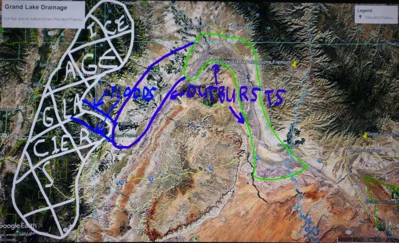
- Grand Lake Drainage (map from Google Earth, notes by Greg Morgan)
Some would reply that the drainage could have been carved by the draining of the Flood waters as the ocean basins dropped to their present depths and the mountains rose up. This would result in a flat-bottomed drainage, with the steep cliffs above. This area was, indeed, probably initially cut out by the receding Global Flood.
However, the greatly increased precipitation immediately after the Flood and during the Ice Age would have resulted in high water flows from the side canyons, and each one would have carved a canyon into the floor of the drainage. These side canyons include Price River and Saleratus Wash, which cross the drainage, and numerous, usually dry, side canyons that empty into the drainage. As precipitation lessened, the streams would have continued to flow through these canyons, further eroding the floors. This would result in steep canyons cut into the floor of the drainage.
Instead, the side canyons have left deltas in the drainage, where the streams have deposited their sediment. These deltas indicate that the side streams have flowed at or near their present seasonal flows since the drainage was flattened. This is consistent with a recent formation of the drainage after the high post-Flood and Ice Age precipitation had ended.
Thus, while the drainage may have been partially caused by the late stages of the global Flood, the drainage was deepened and carved flat at the end of the Ice Age.
Further, the drainage ends where Grand Lake is posited to be. That is, the drainage falls from 5,700 feet elevation at Cleveland, Utah, smoothly decreasing to 4,145 feet at Green River, Utah. The terrain then rises to 4,228 feet five miles south of Green River.

What caused the flow to stop cutting downward, if not that the flow had entered a lake? The flow is expected to continue to cut for some distance below where it hit the lake, perhaps more than a mile, because the flow forces the lake water out, and the dense water-solids mixture flows under the remaining lake water.
The Utah Geological Survey reports that the Wasatch Plateau, 20 miles west of the drainage, was covered by extensive glaciers at the maximum Ice Age. One lobe of the Wasatch glaciers reached within 10 miles of the western edge of the drainage.
I propose that that lobe was the source of a massive glacial outflow, streaming down either Ferron Canyon or Cottonwood Canyon, both of which are U-shaped with flat bottoms. When these streams reached the drainage, they spread out, and the 1,000-foot deep by one-mile wide streams became an eight-mile wide by 125-foot deep flow.
The consideration below requires that two or more canyons carried the glacial outflow, resulting in a 250-foot deep flow in the drainage. That flow went mainly downslope in the drainage, or northeast toward what is now the town of Castle Dale, then over Price, Utah, and curved southeast toward Wellington, Woodside, and finally, Green River, Utah.
During that flow, the leading edge slowed due to friction, and incorporated the rocks and soil it eroded, allowing the remaining flow to catch up and deepen the total flood. At Green River, the flood entered Grand Lake. From the width between the cliffs, this flow was five to eight miles wide. To flatten the bottom to a one-degree slope through a depth of 400 feet, the flow had to be at least 500 feet deep, and it was probably far deeper.
With a width of eight miles and a depth of 500+ feet, the initial glacial outflow was rapid. As it flowed toward Grand Lake, on a downslope of 1,500 feet in 25 miles, it accelerated to 100 miles per hour, similar to the reported flows during the Lake Missoula Flood in Washington State.
When the glacial outflow hit Grand Lake, it caused an impact wave that was similar to the mega-tsunami in 1958 in Lituya Bay, Alaska, which was a 1,720-foot-high wave caused by a rock fall into the ocean. That rock fall involved about 30 million cubic meters, 90 million tons, of rock falling several hundred meters into Lituya Bay, at an impact velocity of 80 meters per second (179 miles per hour).
A glacial outflow, large enough to carve the drainage below Woodside, Utah, flowing into a 3,000-cubic-mile lake, would have created a water-and-soil slurry. The outflow volume would have spread across 8 miles to a depth of 500 feet and traveled at 100 miles per hour, or 44.7 meters per second.

This would cause a wave similar to the Lituya Bay wave — well over 500 hundred feet high. The wave would impact shores and break up into multiple, still enormous, waves. These waves would have eroded the lakefront terraces away. When this wave, still about 200 feet high, hit the earthen dam that formed Grand Lake, the force would have collapsed the earthen dam, beginning the drainage of Grand Lake, and causing the erosion of the Marble-Canyon-to-Grand–Canyon Complex.
The Great Denudation, the removal of 30,000 cubic miles of rock, may have begun earlier, during the recessional phases of the Global Flood, but was increased by this event.
With Grand Lake’s earthen dam destroyed by the tsunami-wave remnant in less than 15 minutes, Grand Lake could have drained in about three days, with a flow averaging 1.7 billion cubic feet per second — or 8,310 times the flow over Niagara Falls. This would have been enough to perform the Great Denudation, and the carving of the Grand Canyon.
The amount of rock removed from the terrain above the Grand Canyon was 15,000 square miles by 2 miles depth, or 30,000 cubic miles. Since this was dispersed into 3,000 cubic miles of water, the resulting density seems too high to support. However, the rock that was eroded was not dry sandstone. The rock was well-saturated and barely cemented together. Sandstones have 10 to 35 percent pore space, or space between the grains.
Since the Ice Age had kept the sandstone moist, there could have been about 25 percent water within the material to be eroded. Therefore, the actual water content of the water-sand-rock slurry could have been 10,500 cubic miles, while the solids content was 22,500 cubic miles, or 2.14 times as much solid material as water. For that slurry to flow, the speed would have had to remain above 12 miles per hour, as essentially a concentrated lahar.
The average slope was a 4,500 foot drop in elevation over the 750 mile route from the earthen dam to the Sea of Cortez (Gulf of California), or 6 feet per mile. The known lahar flow down the slopes of Carbon River, Washington continued to flow to Puget Sound, which is a drop of 235 feet in another 50 miles, or 4.7 feet per mile. So, lahars need steep slopes to initiate flow, but once mobilized, hyper-concentrated lahars only need a slope of 4.7 feet per mile to continue to flow.
This slope was available: a steep slope from the dam through Marble Canyon to the exit from Grand Canyon, during which the flood excavated enough rock to become a lahar, followed by a slope of five feet per mile which maintained the lahar flowing until it reached the Sea of Cortez.
Volcanic Flow into the Grand Canyon
Further analysis of the timing of the excavation of Grand Canyon indicates that the timing of the volcanoes in the western Grand Canyon is key.
- Mount Saint Helens erupted during the Lake Missoula Flood, apparently triggered by the approaching flood as the front wall pounded into hills and cliffs, causing earthquakes — some of which were Richter 6 or above, within 20 miles of Mount Saint Helens (total gravitational energy of glacial Lake Missoula was equal to the energy of two Richter 7 earthquakes).
- Richter 7 and above earthquakes have been shown to trigger eruptions up to 700 miles away.
- The Great Denudation was from a lake containing six times as much water as Lake Missoula, with an average elevation as high or higher — containing the energy equivalent of 12 Richter 7 earthquakes.
- The Denudation and subsequent uplift would have induced many Richter 6 and Richter 7 earthquakes.
- These earthquakes, especially those near the lower end of Grand Canyon, would have triggered volcanic eruptions.
- These eruptions flowed down the side of the newly dug Grand Canyon, some creating dams hundreds of feet deep.
- The lava flowed across the floor of the Grand Canyon, while the Ice Age-engorged Colorado River water backed up behind it, in contact with the lava. This ensured that the lava was weak as it cooled.
- The remaining flow from Grand Lake, and the flow of the Colorado River, eroded the lava back to the level of the Grand Canyon floor.
To confirm this, we should look for short sections of surviving beach terraces, at 5,400 feet elevation or slightly above, around the margins of Grand Lake. Local storms on Grand Lake would have carved these beach terraces. The surviving sections are likely to be in sheltered coves and bays, less affected by the mega-tsunami waves.
One potential site is around the ghost town of Sego, Utah; another is just west of Sego, on Thompson Canyon Road; and others could be along canyons cut into the Book Cliffs.
There also should be some lower elevation beachline terraces, carved when Grand Lake was at lower levels. These terraces may have been protected from the tsunamis by the Grand Lake water itself. Google Earth shows potential beach terraces in several such locations, but field work by competent geologists is needed.
See also: “Shoreline Transgressive Terraces: Tufa-encrusted Landforms Indicate Rapid Filling and Failure of Hopi Lake, Western Bidahochi Basin, Northeastern Arizona ” by Steven A. Austin, Edmond W. Holroyd III et al. about the Bidahochi Basin/ Hopi Lake strandlines and shorelines. This lake occupied northeast Arizona in the Little Colorado River region east of the Grand Canyon, in the post-Flood timeframe, contiguous with Grand Lake. This indicates that the beach terraces may be shallow, but continuous within the sheltered coves and bays, and there may be several terraces within a short distance.
We should also look for another type of evidence.
Slurries of rock, sand, and water are non-Newtonian fluids. That is, they do not begin to flow until a critical stress is reached; then, they flow until the stress on the fluid is reduced below the critical stress level for that density and resistivity. When the stress is lowered, the fluid slows, then suddenly stops, becoming as solid as cement. When the glacial outburst flow reached Grand Lake, and then entered the region where the upslope begins, the slurry would have hardened instantly.
Field geologists should examine the sandstones and mudstones for evidence of lahar-like behavior, especially swirls and whirlpools that suddenly ceased to flow. The field examinations should look 10 miles southwest of the city of Green River, Utah, where the downslope becomes an upslope toward the south. The curved ridge at 4,400 feet elevation should map out the furthest south potential site of the lahar-like deposits, which are easily accessible on three roads, especially Nine Mile Wash Road and Trail Reservoir.
Conclusion
I believe that the Great Denudation, the carving of Grand Canyon, and the volcanoes that flowed down Grand Canyon’s wall all happened near the end of the Ice Age. They were initiated by a glacial outflow which created tsunamis in Grand Lake. These tsunamis eroded away the terraces which had existed around Grand Lake, and destroyed the Grand Lake earthen dam. Grand Lake drained in about three days, with a flow averaging 1.7 billion cubic feet per second — or 8,310 times the flow over Niagara Falls. The Grand Lake drainage eroded everything downstream, leaving the Great Denudation and carving out the Grand Canyon.