[Originally published as Google Earth shows Appalachians were eroded by receding floodwaters]
These two Google-Earth images provide further evidence the Appalachians were eroded by the receding waters of Noah’s Flood. They are of the border between the Coweeta River and its adjacent watersheds. The Cullasaja River is a tributary of the Coweeta River, located to the east of it, and flows towards the north.
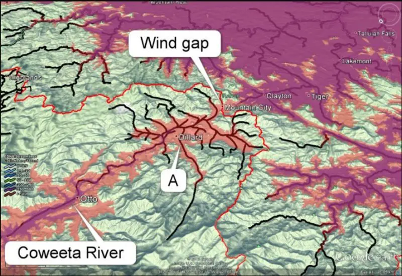

In the first image, the divide between the Coweeta River basin and the neighboring Savannah River watershed is shown as a red line, with the Coweeta basin to the left of the divide. Elevations below 700 m are in pink, and below 630 m are in purple. The image shows a wind gap between the two basins. This is indicated by an arrow where a pink connection runs across the red line of the divide, demonstrating a former connectivity between the two basins.
The problem for Gallen et al. is explaining the formation of the wind gap in their model. The gap is erosional, that is, formed by water, though its orientation may have been influenced by faulting. In addition, the angle of tributary “A” suggests that it used to flow toward the gap because tributaries have a V shape in the downstream direction, whereas this one is “V-ing” upstream. Similar V-shapes have been used by other geologists to argue for stream rearrangement to the north of this area.
It could be postulated that the Coweeta captured the tributary from the Savannah watershed, but stream capture is thought to be favored by a steep slope on the side of the capturing stream, which is not the case here. In fact, the steepest slope is on the Savannah side of the divide, which should suggest that it should be doing the capturing, not the other way around.
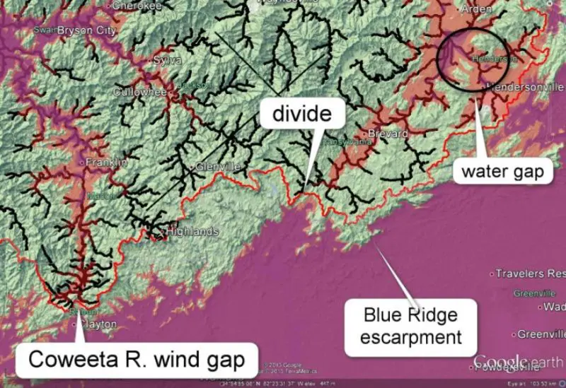
A simpler explanation would be that, as the landscape emerged from inundation (during Noah’s Flood), water currents caused the erosional gap. As they subsided, the flow divided into two currents, one flowing toward the Mississippi and the other to the Atlantic, leaving this and other features such as water gaps in their wake (see circled areas in the second image). The knickpoint retreat referenced in Gallen et al. could have been caused by a sudden steep base level fall as emergence continued, followed by a standstill as the majority of floodwaters reached the Gulf of Mexico. After that, normal stream erosion would have taken over.
Note in the second image that the Blue Ridge Escarpment does not coincide with the drainage divide—another problematic feature of the area (see this link on the Origin of the Blue Ridge Escarpment, southern Appalachians for more information).