[Originally published as Appalachians eroded by receding waters of Noah’s Flood, new GSA paper shows]
An interesting article, published in GSA Today (a publication by the Geological Society of America) in February 2013, describes features of the landscape of the Appalachian Mountains. These are a system of mountain ranges in eastern North America, extending from around Atlanta, Georgia, north past New York, and into Canada. The paper is entitled Miocene Rejuvenation of Topographic Relief in the Southern Appalachians.
This title would not mean anything to most people, because, like most geological articles in geological journals, this one is written in technical language, making it difficult for a layperson to follow. So I’ll post the abstract below with my lay-friendly comments interspersed.

Conventional wisdom holds that the southern Appalachian Mountains have not experienced a significant phase of tectonic forcing for >200 myr;
In other words, the Appalachians were uplifted over 200 million years ago and have not been uplifted since. This means the Appalachians are considered a very old mountain range that has been exposed to normal weathering processes (rain, snow, ice, erosion, landslides, etc.) for hundreds of millions of years. (I’m quoting their figures, but the idea of millions of years comes from evolutionary assumptions, which I don’t accept, and which I discuss a bit more later.)
yet, they share many characteristics with tectonically active settings, including locally high topographic relief, steep slopes, incised river gorges, and frequent mass-wasting events.
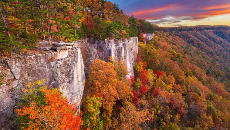
But the problem is that, although the Appalachians are thought to be old, they have lots of features that look really young: tall mountains and low valleys, steep escarpments, and deep river gorges with steep sides.
Two competing hypotheses are commonly used to explain their modern topographic expression. One suggests that relief is largely controlled by variable lithologic resistance to weathering and that their modern form has long persisted in a dynamic equilibrium. The second postulates that their relief is a product of recent rejuvenation, driven either by climate change or the epeirogenic uplift of the land surface driven by mantle forcing.
There are two competing explanations that geologists use to try to get around the problem. The first is that the hardness of different rock strata varies in such a way that the landscape just happens to weather such that it looks young even though it has been weathering for hundreds of millions of years.
The second is that something happened recently to cause a new bout of weathering and erosion, and the features look young because whatever happened only happened recently (geologically speaking).

One idea for this something that happened recently is a change in the climate. (Someone had to suggest that. It’s par for the course these days for climate change to be invoked somewhere.)
Another idea for this something that happened recently is that the continent was recently uplifted. (That’s what epirogenic means: that an enormous area of land uplifted without much folding of the sediments upon it. It was not just the Appalachians that was uplifted, but a huge area around them. The area is considered to have been uplifted from below the continental crust by vertical upwelling of the mantle.)
Within portions of the Cullasaja River basin of the southern Appalachians, we show that relief has increased by >150% since the Miocene.
Here they describe the extent to which the land surface has become eroded to produce deep gorges and steep escarpments. It’s significant. And they put a time on it. It has occurred since the Miocene, which is somewhere around 15 million years ago, within the evolutionary worldview. That is much more recent than the 200-million years idea.
Evident within the basin are a set of retreating knickpoints that delineate a rugged, actively incising landscape from lower-relief relict topography. Constraints on the timing of knickpoint entry into the basin suggest that the process of landscape rejuvenation began well prior to the late Cenozoic (<4 myr) transition to a more oscillatory (glacial-interglacial) climate regime.
Here they describe how they have measured various slopes on the landscape and determined that the renewed erosion was active until about 4 million years ago—i.e. before the Ice Age. So they established that the time range for the erosion was from 15 million to 4 million years ago.
Furthermore, the geomorphology of the Cullasaja River basin is difficult to reconcile in the context of a transition to a more erosive climatic regime but is consistent with an epeirogenically uplifted landscape.
Here they dismiss the first explanation put forward to solve the problem. They say that the shape of the landscape is such that the erosion was not caused by climate change.

Consequently, these observations lend new support to the idea that the rugged topography of the southern Appalachians has developed in response to post-orogenic regional uplift in the Miocene.
In other words, the erosion of the landscape began long after the Appalachian Mountains themselves were pushed up. Further, the erosion that produced the young-looking features was caused by the whole continent (or a large part of it) uplifting with minimal folding or disturbance of the geology.
Discussion
I found this article from GSA Today interesting. The sequence of events that unfolded during the biblical Flood easily explains what the authors have found. Of course, within the biblical way of thinking, we should not be put off by the ages quoted of millions of years. The timing has to be reinterpreted within the biblical model. When they speak of 200 million years, it’s getting toward the middle of the Flood. When they say 15 million years, it is toward the end. And 4 million years is around the beginning of the post-Flood period. These are rough numbers, but a clearer picture emerges when we consider each local area on its merits.
First, the strata that make up the Appalachians were deposited during the first half of Noah’s Flood as the waters were rising. The Flood occurred 4500 years ago, and the first half lasted about 150 days.
Second, the Appalachian Mountains were folded and formed by the Appalachian orogeny (i.e. the Appalachian mountain-building event), which occurred about halfway through the Flood, or just before. By this stage or soon after, the whole earth would have been covered by water, including the North American continent.
Third, the newly formed Appalachian Mountains were eroded as the waters that covered them began to recede into the Atlantic in the second ‘half’ of the Flood. The waters began to flow off the continent because the continent began to be uplifted, and the ocean basins began to open up (or sink). The water initially flowed off the land in sheets, greatly eroding the surface. The resultant surface would be undulating to flat. Secular geologists, who do not believe in the Flood, have mistakenly interpreted the flat and gently undulating surfaces as caused by long periods of sub-aerial weathering. This second ‘half’ of the Flood (until Noah disembarked from the Ark) lasted some 220 days.
Fourth, as the waters continued to retreat from the continent, parts of the land surface emerged above the water, and the receding water then eroded valleys and gorges in the areas that remained submerged. As the water level continued to drop, the valleys and gorges were eroded deeper. This explains why the river gorges in the Appalachians (and all other mountain ranges around the world) cut straight through the ranges (rather than going around them). These erosional features of the landscape look young because they are young. (See Do rivers erode through Mountains and the pdf about the Eastern Structural Front of the Appalachian Mountains for more on rivers flowing through mountain ranges.)
The timing constraints in the GSA Today paper suggest that the landscape in this area emerged from below the retreating waters of Noah’s Flood somewhere around the Miocene (although we have to be careful in trying to make a one-for-one correlation with the geologic column).
Fifth, the Ice Age began to develop immediately after the Flood (which provides the only plausible explanation for it). The ice cover grew on the continents for some 500 years and then retreated for the next 200.
Conclusion
The biblical Flood provides a coherent model and elegantly explains the geological evidence in the Appalachians published in this recent GSA Today paper. When we examine the shape of the landscape (i.e. geomorphology), we have a powerful tool for understanding the sequence of large-scale geologic events and their relative timing. The Flood model gives insights into the processes that were occurring, how these processes changed with time, and stimulates ideas for how to explain the evidence that is being uncovered.
Reference
Sean F. Gallen, Karl W. Wegmann, DelWayne R. Bohnenstieh, Miocene rejuvenation of topographic relief in the southern Appalachians, GSA Today 23(2):4–10, February 2013.