[Originally published as Gold in Victoria, Australia, formed as Noah’s Floodwaters were rising]
In January 2014, I visited Bendigo in Victoria, one of the towns made famous when gold was discovered locally in 1851. During the ensuing gold rush to the region, the Australian population tripled in just ten years.
The gold in the area formed during Noah’s Flood and the geology of the area is nicely explained using the biblical Flood model.

Geological overview
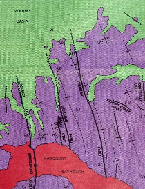 The map (figure 1, 45 km wide and 70 km long), shows the simplified geology of the area around Bendigo, which is located in the middle at the point marked G1.
The purple area is where the gold is found. It is composed of a thick deposit made up of layers of sediment that have been folded along a north-south axis into a repeating sequence of folds. The folds in these sediments are cut by quartz veins, or ‘reefs’, containing the gold, and are mined underground by shafts from the surface. The sediments are slightly metamorphosed and have been extensively faulted, making their geological structure quite complex. These sediments have been classified as Ordovician within geological timescale on the basis of the fossils they contain.
The red area to the bottom of the map is a large granitic intrusion that was emplaced within the sediments. This has been classified as Devonian within the geological timescale.
The green at the top of the map is an area of sediments that were deposited late geologically at the southern edge of the Australian continent in a large area called the Murray Basin. These sediments were deposited on top of the gold-bearing sediments and they still mostly lie horizontally. They have been classified as Cenozoic within the geological timescale.
Rock relationships
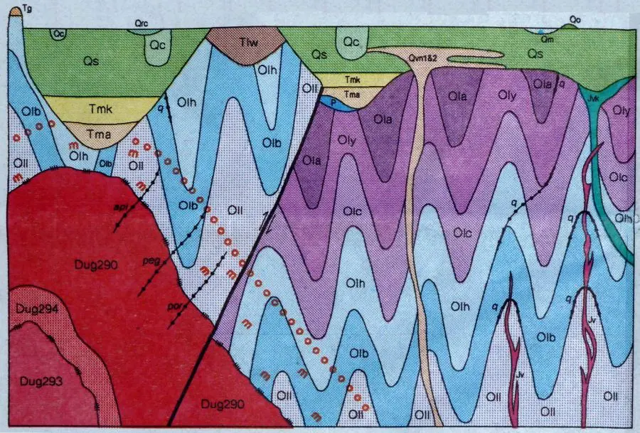
Let’s now look at a diagram (figure 2) that shows how the rocks of the area are related.1 From this diagram we can develop a simple geological scenario that explains the sequence of events in the area.
In figure 2, which is basically a west-east cut across the area, the gold-bearing sediments are shown as wavy layers coloured purple and blue. They are all labelled O for Ordovician, with the different colours and the different labels representing different fossil zones.2
Floodwaters rising
Originally, these layers of sediment would have been laid down horizontally. The strata have been described as turbidites,3 which represent turbulent underwater sediment flows. These are rapid deposits and modern examples have been clocked as travelling at up to 100 km per hour. Around Bendigo they consist of sandstone, siltstone and mudstone. The presence of mudstone has been interpreted as slow deposition in a low-energy environment,4 but recent laboratory experiments show that mud can be deposited rapidly from flowing water.5

Judging from the timing of the sediments of the Great Artesian Basin,6 these turbidite sediments would have been deposited during the middle part of the first ‘half’ of the Flood. That is, it would have been as the floodwaters were rising (Ascending phase), and as enormous volumes of sediment were being carried into the ocean by the catastrophic flows of floodwaters.
After the thick sedimentary pile was deposited, still in the Ascending phase of the Flood, massive tectonic movements occurred in the crust of the earth, likely as the earth’s crust continued to adjust to the progress of the enormous Flood catastrophe. These movements folded the sediments, slightly metamorphosing them.
Also, these crustal movements melted parts of the crust generating volumes of molten rock, or magma, which pushed through cracks (feeder dikes) in the earth and accumulated within huge magma chambers in the sediment pile. As the molten magma crystallized progressively into granodiorite (a granitic rock), the melted rock became more concentrated in lower-melting-point minerals and fluids. Some of these were particularly aggressive in dissolving minerals, and had concentrated much gold in solution. These fluids eventually pushed up through cracks in the folded sediments, with the quartz crystallizing along with the gold in what are today called ‘reefs’. These quartz reefs containing gold are represented by the dotted line labelled “q” on figure 2.
As the floodwaters continued to rise, more and more sediments were deposited on the continent of what is now Australia, including the Mesozoic sediments that contain dinosaur fossils.6 These were deposited as the floodwaters were reaching their peak, during the Zenithic phase of the Flood. Such sediments were almost certainly deposited over the Bendigo area, but there is no sign of them in the area now.
Floodwaters receding
After the floodwaters reached their peak, ongoing movements in the earth’s crust began to lower the ocean basins relative to the continents. The floodwaters began to recede from the continent into the ocean, and during this time they eroded much sediment that had previously been deposited.
It seems that one of the major directions in which the waters flowed from the continent was to the south through the area of Victoria. This receding floodwater eroded the Mesozoic sediments especially in the Victoria region, exposed the underlying folded, gold-containing sediments and the granite pluton. Because the Ordovician sediments have been folded, you can see on figure 2 how much of these sediments have been eroded away.
The final period of erosion was most likely by the receding floodwaters, although there were periods of severe erosion on sediments as the floodwaters were rising. By looking at the top level of the Ordovician sediments we can see that most erosion seems to have occurred before the final movement on the major fault, and that after this movement the top surface has remained quite uneven.
As the energy of the receding floodwaters reduced, they changed from an erosive agent to a depositional one. It was thus late in the Flood that the sediments shown as brown, yellow and green on figure 2 would have been deposited.

It was during this time, late in the Flood, when the Ordovician sediments and their reefs were being eroded, that the gold was being deposited in alluvial sediments, some of which have been called ‘deep leads’. It was this alluvial gold that was first discovered in 1851, which lead to the influx of miners into the goldfields. When the alluvial gold was mostly worked, miners turned their attention to the quartz reefs and extracted the gold from these by underground mining methods and impressive gold processing plants.
Conclusion
So, the geological information published in the standard geological maps and reports can be simply reinterpreted into the biblical Flood scenario based on other areas that have been already reinterpreted. One interesting aspect of such an interpretation is that the processes are connected together into a related sequence driven by the major crustal processes at work during the year-long global Flood catastrophe.
References and Notes
- Wilkinson, H.E., Cherry, D.P., King, R.L., Malone, M.P., Willman, C.E., and Byrne, D.R., Bendigo, and Part of Mitiamo 1:100 000 Geological Map, Geological Survey of Victoria, 1995.
- Cherry, D.P., and Wilkinson, H.E., Bendigo, and Part of Mitiamo, Geological Survey of Victoria, Report 99, pp. 18–23, 1995.
- Cherry and Wilkinson, ref. 2, p. 16.
- Cherry and Wilkinson, ref. 2, p. 17.
- Walker, T., Mud experiments overturn long-held geological beliefs: A call for a radical reappraisal of all previous interpretations of mudstone deposits, 9 January 2008.
- Walker, T., The Great Artesian Basin, Australia, J. Creation 10(3):379–390, 1996.