[Originally published as Mount Warning, New South Wales, erupted late in Noah’s Flood]
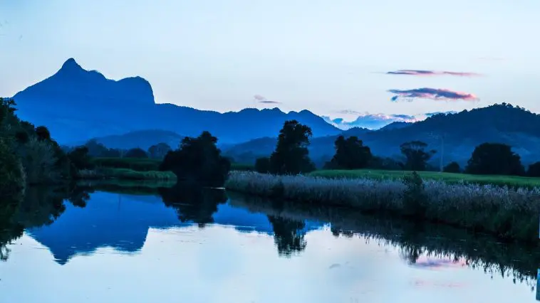
Mount Warning with its distinctive bulbous flank rises 1156 metres [3792 ft] above sea level in northern New South Wales. Lieutenant James Cook named the mountain on 17 May 1770 as he sailed up the east coast of Australia. The mountain, also known as Woolumbin, is what remains of the central plug of an enormous shield volcano that erupted as the waters of Noah’s Flood were receding from the continent of Australia.
The volcanic eruption of Mt Warning was part of a larger sequence of volcanic eruptions that have left plugs and basalt plateaus all along the eastern coast of Australia from north to south. These eruptions were likely the consequence of the floor of the Pacific Ocean sinking relative to the Australian continent in the second half of the Noah’s Flood, creating space to receive the floodwaters that were covering the whole landscape.

Google maps (figure 2) provides a good view of the present landscape around the volcano. (It covers an area 100 km east-west and 70 km north-south.) As Mt Warning was erupting, it delivered black basaltic lava to the land surface (likely underwater) at an enormous rate, lava that flowed at least 30 km in all directions away from the vent. You can see the extent of the lava flows on the map, as they radiate from the centre like long thin branches.
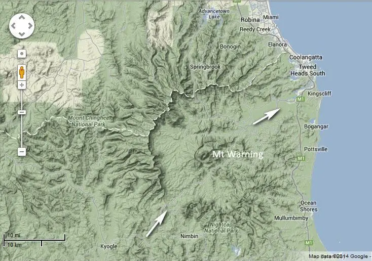
Arrows show area of escarpment that has been eroded away, and the direction that the receding waters of Noah’s Flood flowed.
Once the eruptions ended, the central basaltic shield was incredibly eroded, leaving a steep cliff running in a circle around the central plug, at a distance of about 15 km. Between the escarpment and the plug, an undulating, doughnut-shaped area has been left surrounding the plug, an area that is fertile and used for growing sugar cane. It’s also a popular tourist area.
Interesting features that are nicely explained by the events of Noah’s Flood:
- In spite of the erosion that has occurred, the shield shape of the volcano and its central core are still basically preserved. This helps work out the timing of the eruption. It must have occurred after the intensive, erosive phase of the receding floodwaters had passed.
- But, because such a large volume of material has been eroded, the waters of Noah’s Flood must still have had lots of erosive potential remaining. They likely covered the area to a significant extent and were able to accomplish significant erosion as they drained the continent and receded into the ocean.
- The area around the central core that has been eroded away is much larger than the size of the Tweed River that flows through the area and out to sea to the northeast. This is a classic example of an overfit valley, where the valley is much larger than the dimensions of the river within it. This is not the sort of erosive landscape that would be produced over millions of years by the small rivers that drain the area at present.
- The circular escarpments of the shield that surround the eroded central doughnut landscape are sharp and steep indicating that the erosion was recent. If the erosion had occurred over millions of years there would not be steep escarpments as we see.
- The circular escarpment has been eroded away in two places indicated by the arrows on figure 2. These gaps are a tell-tale signature of the receding waters of Noah’s Flood. The water was likely quite deep over the landscape and flowed in the direction of the arrows as it receded into the ocean.
The escarpment in the areas near the arrows was likely a little lower than the other parts of the shield, so more water flowed in these areas, eroding these sections. As the ocean level dropped, the water continued to flow through these areas creating the gaps.
The wide gap to the north is a water gap, with the waters of the Tweed River flowing through the area. The Tweed River is much smaller than the gap that has been eroded away. The gap to the south could be called an air gap because water does not flow through the area. Rather, at the rim there is a watershed, with streams now flowing north and south from the rim area.
These are some of the features of the Mount Warning shield volcano that visually point to the reality of the biblical Flood. Once you can see the sorts of features that Noah’s Flood produced, and what they look like in a landscape, you can see features like them everywhere because the Flood was a global event.