[Originally published as 1000 feet of Permian sediments removed from the Canberra region, Australia]
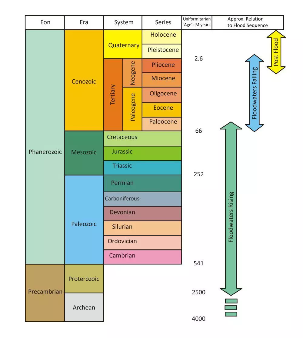
One interesting feature of the rocks around Canberra is that they are confined to a small time-interval on the geological column, that is from the Middle Ordovician to the Late Silurian on the geological column. Rocks from later parts of the geological column, that is, from the Late Silurian to the Tertiary are absent. Since these rocks are present in other parts of New South Wales, we envisage that they would have been deposited in the Canberra area too, but removed by erosion after the waters of Noah’s Flood covered the region and then receded back into the ocean.² (I explain this in my article The geological history of Canberra, Queanbeyan and Environs.)
Ulladulla geological map
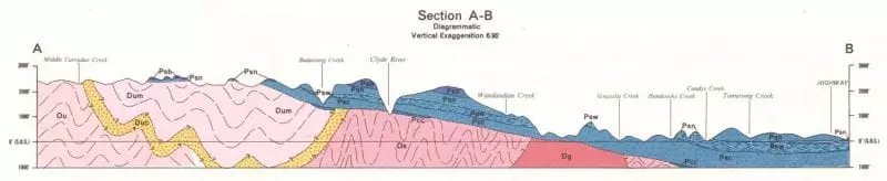
Further to this, the geological map adjacent to Canberra to the east, called Ulladulla,³ throws some light on some of those missing rocks. Figure 2 shows an interpreted geological cross section A–B running west-east across this map.4 The width of the section is 70 km and the thickness of the pink rocks on the left side is 1,000 metres (3,400 feet). The rocks shown on the section extend as far as 300 metres (1,000 feet) below sea level. The vertical scale is exaggerated by a factor of 6.92 times compared with the horizontal scale.

Notice that to the west (left) of this section, toward Canberra, the rocks are shown as pink and red. They are shaped like a huge wedge with the point facing to the east (right). These rocks span a similar time interval as the rocks around Canberra, and they are similarly folded, as indicated by wavy lines on the diagram. As with Canberra, we envisage that this folding produced voluminous magma, which erupted at the time (wavy orange band) and pooled underground forming large granite plutons (shown as red). Thus, the pink/red rocks are similar to the rocks in the Canberra region.
Ulladulla geological section
A further similarity is that the elevation of the land to the left of the section (2,400 feet, 730 metres) is about the same as the Canberra region (Black mountain = 812 metres). You can see on this section that the tops of these rocks have been eroded forming a wide plateau that is part of the Great Dividing Range.
To the right of the section, the rocks coloured blue sit below sea level to the east (right) and run up the slope of the pink wedge, like blankets one on top of the other. Toward the top of the wedge the blue rocks have been cut off at around the same elevation as the plateau.
The sedimentary formations comprising these blue rocks are shown by lines on the section, indicating that the formations are easily traced across the area. The formations have been slightly tilted,5 but they have not been folded. The blue rocks have been classified as Permian (P, see figure 1 for their location on the geological column). The characteristics of these Permian sediments on the section provide an insight into the amount of erosion that took place in the Canberra region.
Notice that the blue sediments are in excess of 1,000 feet (300 metres) thick. None of these sediments has been preserved on the uplifted plateau to the west (left) of the section. However, as we move toward the east some small isolated remnants of the blue sediments have been preserved on the hills of the plateau. Farther east we encounter the tops of the formations at the top of the wedge slope.
It is clear from the way the formations have been truncated that the Permian sediments must have extended right across the Canberra plateau to the west. This gives an idea of how much erosion occurred during the second half of the Flood.
However, these Permian sediments are only part of the rock material removed from above the Canberra plateau. Farther to the north in New South Wales and extending into Queensland, these Permian rocks are covered by the rocks of the Mesozoic (Triassic, Jurassic, and Cretaceous; see figure 1). It is likely that these rocks once covered the Canberra region too, but were eroded away when the waters of Noah’s Flood eventually covered the area, and again when they receded into the ocean.

The uneven surface of the blue Permian rocks on the right side of the section reveals something of the characteristics of the receding floodwaters. After the receding water reduced in volume it flowed across the land in wide channels. For example, the deep, wide valleys containing Budawang Creek and Clyde River (figure 2) point to their being cut by a much larger flow currents than the present flow in the rivers and creeks in those valleys now.
Conclusion
Geological cross sections, such as section A–B for the Ulladulla geological map, reveal much insight into the geological processes involved in forming the rocks and landscapes. The Ulladulla section (figure 2) indicates that a large depth of rock material, deposited as the waters of Noah’s Flood were rising, was eroded from above the Canberra Plateau during in the Recessive stage of the Flood, as the Australian continent was uplifted and the waters of Noah’s Flood were receding into the oceans.
References and Notes
- There is not a one-to-one relationship between the column and Flood rocks because the criteria used to place rocks within the evolutionary column are not always applicable to a Flood classification. See Oard, M.J., The geological column is a general Flood order with many exceptions, J. Creation 24(2):78–82, 2010; creation.com/geologic-order. To assign rock units to biblical history, the geology of each geographic location needs to be considered on its merits using biblical classification criteria.
- As indicated in figure 1, I envisage that the peaking of the Flood was around the top of the Cretaceous.
- Rose, G., Ulladulla, NSW, 1:250000 Geological Series, Sheet SI 56-13, 1st Edition, Geological Survey of New South Wales, 1966.
- More precisely, on the map section A–B extends from a south-west to north-east direction.
- Note that the vertical dimension of the section is exaggerated some seven times, which means the slopes of the formations on the section are also exaggerated.
Update
4 November 2019 A Facebook friend asked a question about this article:
Being a complete novice, I need to ask whether I am correct in thinking the blue rock is the sediment deposited when the flood water rose and then washed down when it receded?
This is my reply:
All of the material shown on this section (figure 2) was deposited/emplaced as the floodwaters were rising. The order it happened is as shown on the geological column (figure 1). The codes on the rocks on the section indicate the order: Os, Ou, Dg, Duc, Dum, and then all the P. O stands for Ordovician, D for Devonian, and P for Permian. (I got the details of the order from the geological map. The geologists got the order from the relationship of the rocks with each other.)
All the sedimentary rocks were deposited by huge water currents, similar to the way water washes sediment into a farm dam. The volcanic rocks either pooled underground (Dg) or erupted onto the land surface (probably Duc). At various times the crust moved, folding the rocks, and water flowed eroding the surface of the rocks. You can work out the timing of these from the relationships on the section.
For example, check the pink rocks labelled Os (the O stands for Ordovician). From the geological map I saw that these are composed of layers of siltstone, claystone, sandstone, etc. These sediments would have been laid down by water in horizontal layers.

Then crustal movements would have folded all the sediments (indicated by the wavy line on the diagram). Then a whole lot of granite magma was pushed into the sediments forming a pool of lava underground (indicated by Dg which stands for Devonian granite). Then the top of the sediments and the granite were eroded (shaved off). This is indicated on the diagram by the way the wavy lines are cut by the surface. This would have been eroded by water flows driven across the land surface by the crustal movements that occurred as the floodwaters were rising.
Then, on top of the pink and red rocks, the blue Permian sediments were deposited by the floodwaters as they continued to rise. As I describe in the above article, lots more sediment was deposited on top, but it has been eroded away, as have some of the blue Permian sediments. I describe this in the article and say that this erosion occurred once the floodwaters reached their peak and covered the whole area, and as they receded into the deepening ocean basins.
As the ocean basins sank and the continent uplifted, the blue sediments were bent upwards slightly, forming the high land of the Great Diving Range. On figure 2 the slope of the blue sediments looks quite steep, but the vertical scale on the diagram is exaggerated. They are not as steep as they appear, and the sediments were not “washed down” as the floodwaters receded. However, the sediments were eroded, and the eroded material was washed away. It was carried completely out of the area by the receding floodwaters and deposited into the ocean, forming the continental shelf and margin to the east off the coast of Australia. (See Continental margins formed rapidly during Flood runoff.)