Fish River Canyon is the second largest land canyon in the world, after Grand Canyon in the USA.1
It’s in Namibia, on the west coast of southern Africa, a country that’s a little larger than Texas, but with only a tenth of the population—just 2.2 million people.
The Fish River flows over a remarkably flat landscape, into the Orange River along the border with South Africa. For three quarters of its 650-km length, the river runs across the land, but in its last quarter it cuts down into the rocks forming the spectacular canyon.2

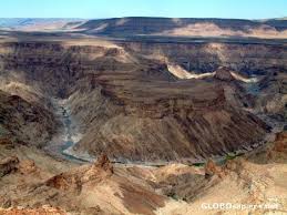
From the tourist lookout near Hobas, you can peer deep into the inner canyon and see the river flowing around a horseshoe bend (figure 1). The overwhelming impression is dryness. The land is arid. The countryside is brown and dusty, and trees are conspicuously absent. During the few months comprising the rainy season the river is muddy and flows quickly in the gorge, but for most of the year it’s just a trickle between strings of water holes.
For all its dryness, the landscape looks like there was a lot of water flowing over it in the past.
In such an arid climate, how would the distinctive landscape around Fish River Canyon have been eroded? For all its dryness, the landscape looks like there was a lot of water flowing over it in the past. Water provides the clue.

Figure 2. Satellite image shows the wide, flat plain has been eroded north-south by Fish River Canyon. Note the multiple side canyons which are characteristic of ponded water draining from the plain. (Image from Google Earth)
Look at the flat plain in the distance across the canyon from the lookout. This flat surface is even more obvious in satellite pictures, as available through Google maps (figure 2). This flat land surface suggests that the area was eroded by a wide expanse of flowing water that eroded the rocks. Flat landscapes are a tell-tale signature of Noah’s Flood, in particular the period in the second part of that event when the waters were receding in wide sheets from the earth.3
Another indication of past water flows is the deep inner canyon itself. Although the canyon is deep, Fish River follows a meandering path. Further, it has maintained the same path as it cut through the thick layers of flat-lying sedimentary rocks and into the underlying metamorphic rocks. In other words, it has not cut sideways on the landscape but downwards. This means that the inner canyon started eroding when sea level was much higher, that the water flow through the canyon was high, and that the sea level fell rapidly so that the water flow eroded downwards rather than sideways.
On the satellite view, notice the multiple, large side canyons projecting from Fish River Canyon. This erosion pattern is another characteristic of Noah’s Flood, signifying the time when ponded water was draining from on top of the plain. The ponded water would have flowed sideways into the main Fish River Canyon cutting the side canyons. The same features are present in Grand Canyon, USA.4

©Christian Goltz

Figure 3. The Hobas View Point visitor information facility at Fish River Canyon provides an excellent vantage point for tourists, plus abundant interpretive information on Perspex signs.
… the geological information on the signs needs to include the biblical perspective.
Notice too that there is very little rock debris in the inner canyon. This means the eroded rock has been carried out of the region by the water. The deep inner canyon is another signature landform of Noah’s Flood, of the period when the waters had mostly receded but were still flowing in large channels. The area around Grand Canyon, USA has similar shaped features.5
Fish River Canyon is one of the most popular tourist attractions in southern Namibia. It’s considered a national monument. A modern tourist resort is located within the canyon at Ai-Ais, and a visitors’ lookout has been constructed near Hobas. Abundant interpretive information has been provided on Perspex signs at this lookout (figure 3), and most of the material is excellent. But the geological information is presented using the geological philosophy that denies that Noah’s Flood ever happened. For people to be able to properly understand what they are looking at, and to make the connection between Fish River Canyon and what really happened on the earth, the geological information on the signs needs to include the biblical perspective.