
Not so very long ago, people were just learning to make fire. They finally invented a stone-chipped wheel, and started using more than just grunts and shoves to talk to each other. They wore only skins draped over one shoulder and they never trimmed their hair or bathed. That’s what most books, movies, and ads tell us. That’s what we all believe, right?
Not God. He made us not too long ago and He made us really smart. The only true thing above is that our first clothes were made of skin. But I’m quite sure God was a better tailor than the ‘caveman’ drawings would have us believe.

I’ve already mentioned how smart people had to be in order to build the huge stone works and some other really smart inventions we find around the ancient world. Here’s another thing they did that you won’t find in kid’s books.
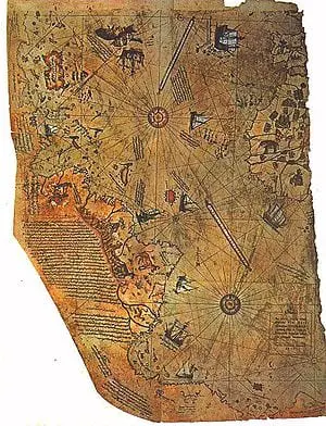
The Piri Reis Map was made in the 1513AD from a collection of 20 or so older maps that dated to the time of Alexander the Great (300BC) and even earlier. It was drawn by a great Turkish admiral (Piri Re’is) who was able to use the Imperial library of Constantinople. We know that it is real, but we don’t know how these ancient people knew what the map shows so accurately.
On the right you can see the coast of Africa, but that’s not so surprising. The Arabs and Phoenicians were known for traveling around that continent. But then we get to the left and the bottom of the map. It shows the east coast of South America very accurately. That is surprising by itself since Magellan wouldn’t explore the coastline that far south for another 7 years.
Then we come to the bottom of the map. Can you see what land mass it shows? That’s right, it’s Antarctica. And it shows the coastline that we can only see with special machines to listen to the ground under the ice. This map describes this area with amazing accuracy that we’ve only matched in the last 50 years.
Another mind-boggling thing (for Evolutionists at least) is the math used to make this map. It is laid out on a grid like we use for our best maps, but you can still see where the originals that Piri Re’is copied had used a very fancy form of “spherical trigonometry” (ask your parents what that means!). You could take a map like that and glue it on a globe! People had to be really smart to make something so accurate.
Some people believe that the perfection of this map’s picture could only have been done from the air. It’s not impossible that ancient people had used some kind of airplane or balloon, but we can only guess. What we do know is that this map and others must have been made before the Ice Age had buried Antarctica and before we lost our ability to travel far and record with scientific precision.
There are other maps that show Greenland as two separate islands. Now we know it would be two islands if all the glaciers were melted off of it!

Don’t forget to check out the page on Ancient Geometry and Mapmaking over at Genesis Verasity Foundation to see some more maps and how much the ancients knew about geometry. James Nienhuis has a post up talking about how we studied the Piri Reis map and how accurate the charting to produce it was.
God’s Word is accurate, we can trust Him and what He tells us about ourselves and our past!!
For the wrath of God is revealed from heaven against all ungodliness and unrighteousness of men who suppress the truth in unrighteousness… Romans 1:18 NASB
Thus saith the LORD the King of Israel, and his redeemer the LORD of hosts; I am the first, and I am the last; and beside me there is no God. Isaiah 44:6
Sites I used to build this post:
World Mysteries Piri Reis Map You folks will enjoy this one, there is a lot I couldn’t fit in!
I got the idea from this page at OOPARTS & ANCIENT HIGH TECHNOLOGY the Christian site (where they don’t always fact check).